Posts

Norfolk to Solomons

Image
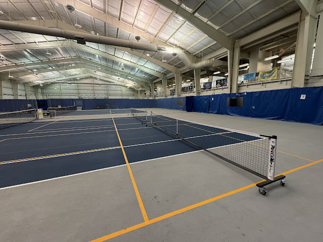
On October 26, 2023, Ann and I left our dock in Annapolis with our new boat Empty Nest to escape the cold Winter. We stayed 3.5 months in Key West, visited the Bahamas, Dry Tortugas, and many towns along the East Coast.  Now, 2,500 nautical miles and 6 months later, we will return to our dock tomorrow. Our first year as snowbirds is almost over, and we already cannot wait for the next one.  Last night the weather was damp with sporadic rain in Norfolk. I found an indoor pickleball facility at Old Dominion University. Since we were not familiar with the area, Ann and I arrived early by Uber to a 3 hour open play session, and the location did not disappoint. In fact, I'd rate the competition as 3.8 to 4.5 level players. Ann and I lost as many games as we won, perhaps even more, which is ideal. Playing better players is the most fun. It was a blast, and the players were super friendly. I think it's the best pickleball we had on the entire trip, not counting our visits home to Anna

Made it to Norfolk!

Image
Bridges, locks, fuel barges, no wake zones, waiting. That sums up our trip to Norfolk today. For those of you that want more detail, you'll find it below. Up early, we pulled up a very muddy anchor. As we headed up the ICW, Ann spent considerable time washing down the deck and the anchor. We passed the famous Coinjock marina, where we had spent the night on our trip down 6 months ago. Seems like years ago. After Coinjock, we enjoyed some open water before the real work began. Timing the bridge openings is tricky. I used to travel the ICW by boat and just wing it. I got there when I got there, and I waited until the next opening. Amateur hour. Now with all the apps and fancy instruments on Empty Nest, we knew exactly how much time we had. The first low bridge that we faced was the  North Landing Bridge. A swing bridge that opens on the hour and half hour. Our electronics indicated that we would arrive at 3 minutes past the half hour, about 40 minutes later. We decided to accelerate

Oriental to North River

Image
Oriental harbor was peaceful this morning. Just a lone sailboat behind us before dawn. A light breeze and slight Westerly waves had the makings of a calm morning for smooth sailing. Our anchor was up at 6:45 a.m., and we were under way. We caught the sunrise on our bow, and everything seemed right with the world. Today's trip was just over 100 nautical miles, which took us about 10 hours. We were inside the Outer Banks on the Pamlico Sound all morning and into early afternoon. Depths were pretty good, but we had to keep an eye on things, and there were many crab pots that we had to avoid, so we could not let our guard down. When we arrived at Manteo, we opted to continue on for two more hours and cross the Albermarle Sound today to shorten our journey to Norfolk tomorrow. The river by Manteo has two bridges. The one pictured below is 66 feet, and the next one is 44 feet high in the center. Any reasonably sized sailboat will have a mast higher than that, so not surprisingly, we did

Wrightsville Beach to Oriental

Image
We are making progress towards home. We even have an approximate arrival day - either Saturday or Sunday this weekend! We left the dock early in Wrightsville Beach, just as the drawbridge behind us was closing and before sunrise. As we pulled out of the inlet, I checked the local tide table and saw that we were at high tide, over five feet above mean low water. This lowered my stress level considerably navigating the last couple of miles on the ICW before entering the ocean. We got into the sea, and the waves were finally as calm as forecast. It was an easy run of about 6.5 hours. We did have one interesting encounter though. We noticed a military vessel up ahead. After about 20 minutes, I got hailed on the VHF, "This is US aircraft carrier one, please alter your course and give us a three mile radius all around. We are conducting military exercises." He was very convincing! Needless to say, I altered course. You can see from the track of Empty Nest on my chart where I veered

Georgetown to Wrightsville Beach

Image
We slept in this morning until about 6:15, and I rushed Ann because I wanted to be on our way as early as possible. We managed to get the anchor up and on our way before sunrise. I grabbed my phone and got a nice picture when the sun came up.  The forecast was great. As you can see from PredictWind, my go-to app, the waves were 1.1 feet with an 8 second period. That's a great prediction from the app. But in real life, we had 3-4 foot waves on our nose. The first two hours were pretty miserable as we dealt with a bouncy ride. We put my office chair down after it almost flew across the room. In a few hours, the seas calmed down, and we had a pleasant ride the rest of the way. After the 65 nm ocean crossing, we entered the intercoastal waterway, with its own set of challenges. We no longer had to deal with waves or rough water, but there are shallow areas all over, and we entered Cape Fear River at the lowest tide. We entered the ICW at low tide at 3:30 pm The ICW is beautiful in many